
Several places have preserved the remains of stone roads built almost two millennia ago, when a large part of the present lands of Romania were part of the Roman Empire. Some ancient roads have stood the test of time and become tourist attractions.
Roman roads, carefully planned by ancient architects and engineers and built from the 4th century BC onwards. BC, were among the most impressive infrastructure works of Antiquity. The huge network of roads that connected Rome to the provinces of the Roman Empire was extended over time to more than 400,000 kilometers, of which more than 80,000 kilometers were paved with stone.
The Romanians excelled in road construction
At the beginning of the 2nd century, during the time of Emperor Trajan, when the first roads in Dacia were built, the length of the roads in the empire exceeded 100,000 kilometers. At the same time, they included over 2,000 bridges and walkways, historians show.
Roads built in Antiquity were of many kinds, from narrow roads called “actus” to wide roads called “via” and built to connect important towns in the provinces, military forts, and trading and mining centers. Some were covered with stone, domed and equipped with gutters for water drainage.
In some areas, roads were dug into the rock, and in swampy and flood-prone places, portions of them were supported on bridges, footbridges, wooden foundations, or piers driven into the rock. Some complex works on the routes of the Roman roads were also identified on the territory of Romania, in the Olt valley and at the Iron Gates, on the Danube. Roman roads benefited from frequent maintenance and repairs to extend their lifespan, originally estimated, according to some authors, at 70 years.
“As everywhere in the empire, the Romans built solid, smooth and wide military and commercial roads, and along them, at certain distances, resting places were erected for travelers, where the shooters were changed. Where the topographical position allowed, watchtowers (speculae) were built, which were intended to supervise not only the roads, but also to observe any foreign violation“, pointed out the historian Traian Simu.
The longest road: from the Danube to Porolissum
At the beginning of the 2nd century, more than 4,000 kilometers of cobblestone and flagstone roads were built on the current territory of Romania, archaeologists showed. Some segments have endured for nearly two millennia, while other routes are still in use today, hidden beneath modern roads.
In the work “Roads from Roman Dacia” (Cluj-Napoca, 2006), the historian Florin Fodorean showed that, in the first years after the conquest of Dacia, the Romans built the main arteries of the province, with a pronounced military character. These roads connected the Danube to the north of the province, the castles on the limes, the large urban centers and the strategic settlements on the Mureș and Olt valleys.
The first two roads used by the Roman armies to advance in Dacia, Lederata – Tibiscum and Dierna – Tibiscum, started from the Danube, one near the town of Baziaș (Caraș-Severin), where the Lederata fort had been established, and the other from Orșova (Mehedinți), the ancient city of Dierna. Around here, the Roman armies crossed the Danube into Dacia on bridges built from vessels, according to historians. Both roads bypassed the Banat Mountains and met at Tibiscum, near Caransebeș.
From Tibiscum, the imperial road followed the route Ulpia Traiana Sarmizegetusa – Apulum – Salinae – Potaissa – Napoca – Porolissum, with a length of over 300 kilometers. Thus, the Roman road continued towards the Sarmizegetusa colony, the capital of Dacia Felix, passing through the Iron Gates of Transylvania, the site of the legendary Tapae.
From Ulpia Traiana Sarmizegetusa (video), in the years following the Daco-Roman wars, the route of the imperial road was extended inside Dacia, on the valleys of Streiului and Mureș, then through the Apuseni Mountains, towards the north of the province, in order to be able to exploit Dacia’s important gold and salt resources. The stone road from the time of Emperor Trajan crossed the ancient cities of Apulum (Alba Iulia), Potaissa (Turda), Napoca (Cluj-Napoca) and stopped at Porolissum (Moigrad), counting, in its stretch from the Danube to the north of the province, more than 550 kilometers.
The old road from Valea Oltului
Another Romanian road followed the route Drobeta – Bumbești – Pasul Vâlcan – Sarmizegetusa.
Called Via Alutana, the Roman road that ascended the Olt Valley passed through the ancient settlements of Sucidava – Romula – Acidava – Rusidava – Pons Aluti – Buridava – Castra Traiana – Arutela – Praetorium – Pons Vetus – Caput Stenarum – Sacidava – Apulum, with a branch to the east, which connected the camps located along the Transylvanian Olt: Caput Stenarum – Cincșor – Feldioara – Hoghiz – Olteni – Bretcu.
In the Olt gorge, like the Roman road from the Danube Cauldrons, it was in some places suspended on beams planted in the slopes, so that the waters would not flood it. His remains were identified in the Racovița-Cornet area, at the exit from the Cozia National Park. According to historians, the road from the Olt Valley, which went up to the Red Tower, was rebuilt in the time of Emperor Hadrian (117–138) and was also used in the Middle Ages, the pass being remembered in the time of voivodes Mircea the Elder and Mihai the Brave.
The secret of the most ingenious ancient road in Dacia. The grandiose construction reached the bottom of the Danube VIDEO
The historian Florin Fodorean mentioned other main roads built in the province of Dacia. These are: Via Transalutana, on the route Flămanda – Putineiu – Băneasa – Roșiorii de Vede – Gresia – Ghioca – Urluieni – Săpata de Jos – Purcăreni – Apa Sărată – Jidova – Câmpulung – Voinești – Rucăr – Râșnov – Brețcu; the road along Mureș: Apulum – Micia – Partiskum; the road that connected the camps on the northwestern limes of Dacia: Bologa – Buciumi – Românași – Romita – Porolissum; the road on the northern border of Dacia: Tihău – Ileanda – Cășeiu – Dej; the same road on the northern border, further, from west to east, in the Dej – Ilișua – Orheiu Bistriței sector; the road that connected the camps on the eastern limes of Dacia: Călugăreni – Sărățeni – Inlăceni – Odorhei – Sânpaul – Olteni – Brețcu.
The forgotten road from Germisara
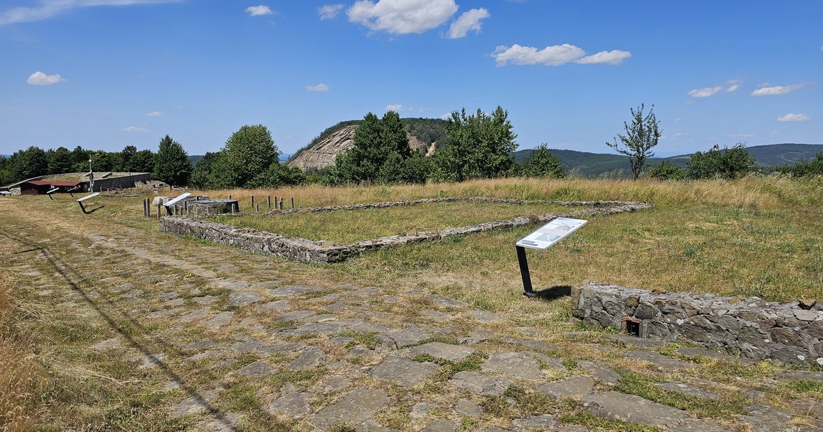
In several places in Romania, tourists can see well-preserved segments of Romanian roads. Such a road is in the vicinity of the Geoagiu Bai resort, called Germisara in Antiquity.
“This Roman road served as a link to the Cigmau castle, being a paved road with polygonal tiles (via silica stratae), and in some places archaeologists have discovered that the depth of the road is 70 centimeters, which justifies the intact preservation of the alleys until now. The road was provided with gutters that collected rainwater. In the Roman era, the roads were generically called “via stratae”, because they were built of several layers. Currently, only this portion still exists, 165 meters long”showed the representatives of the Terra Dacica Aeterna Association, for historical reconstruction.
The road from Germisara represented a branch of the imperial road that went up the Mureș valley, towards Apulum. According to archaeologists, the Roman imperial road passed through Simeria, crossed Mureș at Uroi, an ancient settlement of stonemasons, and then followed the right bank of the river to Geoagiu, where in Antiquity there was a Roman fort, Cigmau, and the famous Germisara thermal baths. The Roman road that passed through Germisara went up to the land of gold in the Metaliferi Mountains.
The ancient road at the northern border of the Empire
In the former ancient city of Porolissum, located in the town of Moigrad, Sălaj county, the amphitheater and the Roman road have remained well preserved. The settlement near Zalău operated as a military camp as early as 106 AD, during Trajan’s Daco-Roman wars, and developed rapidly through trade with the native Dacians. In 124 AD became the capital of the Romanian province of Dacia Porolissensis.
Today, a portion of the Roman road that started from the Danube, more than 500 kilometers to the south, and ended at Porolissum, is kept almost intact here. Also in Sălaj, in Sutoru, the archaeological excavations on the Transilvania Highway route led to the discovery of another well-preserved segment of Roman road, close to the Roman fort Optatiana. The stone road, buried a few tens of centimeters underground, was discovered in 2021, right on the route of the future Cluj-Napoca – Oradea highway.
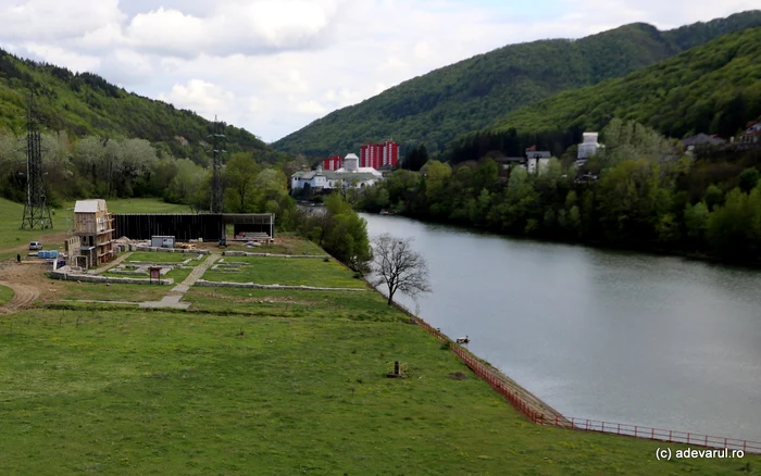
The most spectacular Roman road on the territory of the former province of Dacia was identified in the Danube Gorge, popularly known as the Iron Gates. Here, the Romans built the first suspended road in Dacia, and its remains were preserved until the 60s, when the level of the Danube was raised by almost 30 meters, as a result of the construction of the Iron Gates I Hydropower and Navigation System.
The road swallowed by the Danube
The road was built on the right bank of the river, in the Cazanelor Dunării area, and crossed the gorge on a stretch of about 40 kilometers. Due to the huge rocks and the fact that, in a sector of about five kilometers, the width of the river narrowed to less than 60 meters, the builders resorted to an ingenious solution for the construction of the road. In some places, it was carved into the mountain, and in other areas it was suspended with wooden floors resting on oak beams embedded in the rock wall.
The Dacians built the most durable paved road in Romania. How much will it cost to restore it, after two thousand years
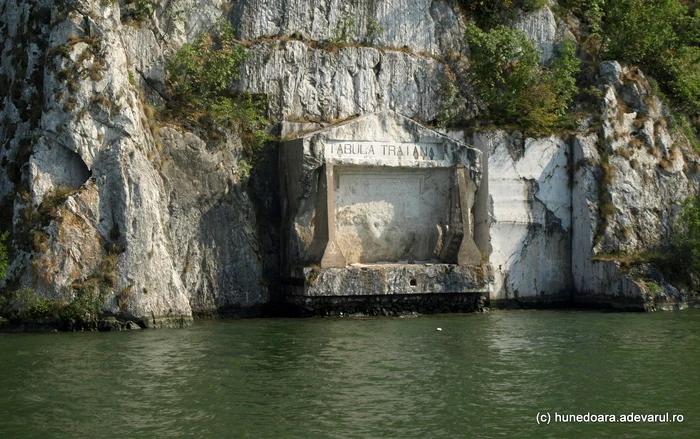
“Among the Roman remains that have been preserved until today, Trajan’s Way is undoubtedly one of the grandest. On the Danube road, from Drencova to Orșova, on the right bank, we see this masterpiece of Trajan’s soldiers, who, on the orders of this emperor, cut the rocks, to make way on the right bank of the Danube. We cannot fully imagine the extraordinary power these industrious workers must have exerted to overcome enormous difficulties to accomplish this great work. The rocks rising immediately to the water’s edge, the workmen had not a palm of earth or stone, had no ships at their disposal for the path of the cut stones, and no powder for splitting them“, the historian Aron Densușianu pointed out, in the magazine Familia (1866).
In the 19th century, the road on the right bank of the Danube was still in use, and on its edges there were, from place to place, ten stone monuments carved into the rock, some called Tabula Traiana, which remembered the efforts made in the construction of the road and paid tribute to the emperor Trajan.
One of the commemorative monuments erected on the road built by the Romans through the Danube Cauldrons is known as Tabula Traiana and has stood for over 19 centuries. In the 1960s, it had to be moved 30 meters higher in order not to end up under the waters of the Danube, with the Iron Gates hydropower development. The road reached the Iron Gates, where the Danube was crossed on the Drobeta stone bridge, the remains of which are still visible today.