
The first indications show a weaker polar vortex than usual, which could lead to a severe winter in Europe and North America.
Three global factors could trigger a “almost perfect storm” in the Polar photo vortex: Archive
The first meteorological data suggests that the polar vortex this winter could be much weaker than usual. This phenomenon could have serious consequences on the time, especially in the United States, Canada and Europe, where the risk of extremely cold and snowy episodes increases considerably.
According to the Severe Weather Europe, three major factors at this time contribute to the formation of a “almost perfect storms ”.
What is polar vortex and why is it important
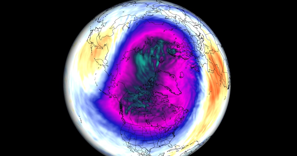
Polar vortex is an area of strong winds circulating around the poles in the winter months, both in the northern and southern hemisphere. It extends vertically into the atmosphere, from the troposphere (the layer in which the meteorological phenomena) to the stratosphere (where the ozone layer) is produced.
Meteorologists divide this vortex into two parts: tropospheric vortex, more chaotic and influenced by the topography of the Earth, and the stratospheric vortex, more stable and symmetrical. There is a close connection between them, and weakening of the stratospheric vortex can have significant effects on the weather.
“A strong polar vortex holds cold air isolated to the north, which means milder winters in temperate regions. Instead, a weak vortex allows cold air masses to penetrate south, triggering severe winter episodes“Explains the experts.
One of the most drastic scenarios is the so-called “sudden stratospheric heating” (SSW), which occurs when the temperature and pressure in the stratosphere increase rapidly. This phenomenon can destabilize the vortex and even “break” it in several cores.
Factors that could weaken the vortex this winter
Three global climatic factors are currently aligned and could decisively contribute to the weakening of the polar vortex:
1. A possible La Niña weak (Enso) El Niño -Southern oscillation (ENSO) is a climatic phenomenon that alternates between hot phases (El Niño) and cold (La Niña) in the equatorial Pacific. Although we are currently in a neutral phase, there are signs that a weak Niña could be installed this winter.
“La Niña was historically associated with an increase in the probability of sudden stratospheric heating, between 60% and 75%, which disrupts the vortex and favors the cold and unstable weather in the USA and Europe.”, Notes Severe Weather.
2. The quasi-biannual oscillation (QBO)-Eastern stratospheric winds QBO is a phenomenon that describes the alternation of the direction of the equatorial stratospheric winds every 17 months. Recent measurements in Singapore show that eastern winds are increasing and will become dominant to winter.
“This eastern phase favors the propagation of planetary waves (Rossby) from the troposphere to the stratosphere, which destabilizes the polar vortex and makes it more vulnerable to collapse.. ”
3. Low levels of ice in the Barents and Kara expanding the sea ice from the polar regions influence the atmospheric circulation and the global pressure. Currently, the data show a accentuated reduction of ice in the Barents and Kara and, simultaneously, high levels in the Okhotsk Sea. A combination that, according to research, favors a weak polar vortex.
“This interaction between the decrease of the ice and the Eastern QBO amplifies the risk of a stratospheric vortex collapse”warns meteorologists.
A possible collapse of the vortex
The publication recalls that such collapse took place in March, when the stratospheric vortex was divided into two distinct nuclei. About 30 days after that event, the high pressure at the North Pole disturbed the jet current and pushed the Arctic air to the south, which led to low temperatures and snow in Europe and North America.
What follows
The combination of the three factors – La Niña weak, East QBo and the decrease of the ice in the Barents/Kara form forms a “global trio” that favors the weakening of the polar vortex in the coming months. This means that there is a high probability for a cold winter, with abundant snowfall, in many regions of the northern hemisphere.
Meteorological models will continue to be updated as winter is approaching, but specialists recommend vigilance and preparations for a possible severe winter.