
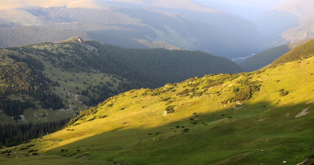
Crossed by the highest road in Romania, the Parâng Mountains offer its guests numerous tourist attractions, some accessible by car. But to discover the most spectacular places in the massif, tourists have to make extra efforts.
Parâng Mountains. Photo: Daniel Guță. TRUTH
The Parâng Massif stretches over 5,000 square kilometers in the Southern Carpathians and is named after its highest peak, the Great Parâng, at 2,519 meters.
The massif includes the Parângului, Căpățănii, Lotrului, Cindrel and Șureanu mountains, located within the Hunedoara, Gorj and Vâlcea counties and bordered by the Olt, Jiu and Strei rivers and their tributaries, which separate them from the Retezat, Vâlcan and Poiana Ruscă Mountains.
The Parâng Mountains, where the most imposing peaks of the massif are located, stretch to the east of the Jiului Valley, not far from the towns of Petroșani and Petrila.
They are distinguished in the mountain range of the Southern Carpathians by the numerous rocky mountain ridges, under which the glacial cirques are found – the so-called caldera, with almost vertical walls, inside which the glacier caps were located in the past.
The hydrographic network of the Parâng Mountains is rich, and their most important river is the Jiul. But there are at least 20 glacial lakes in the alpine area of the mountains that exceed altitudes of more than 2,500 meters
Its waterfalls, caves, caves, gorges, forests and waters make it attractive for tourists, but the most spectacular places in the massif are its peaks. Parângul Mare reaches 2,519 meters, the Gemănarea, Stoinita and Cârja peaks exceed 2,400 meters, and 15 other ridges are over 2,300 meters.
A lot of attractive places are presented to hiking enthusiasts who start on the mountain trails of Parâng.
The truth presents some of them:
The glacial lakes of Parâng
The glacial lakes in the Carpathian chain were formed in the caldera of prehistoric glaciers, by the accumulation of water from rain and snow and by the discharge of springs.
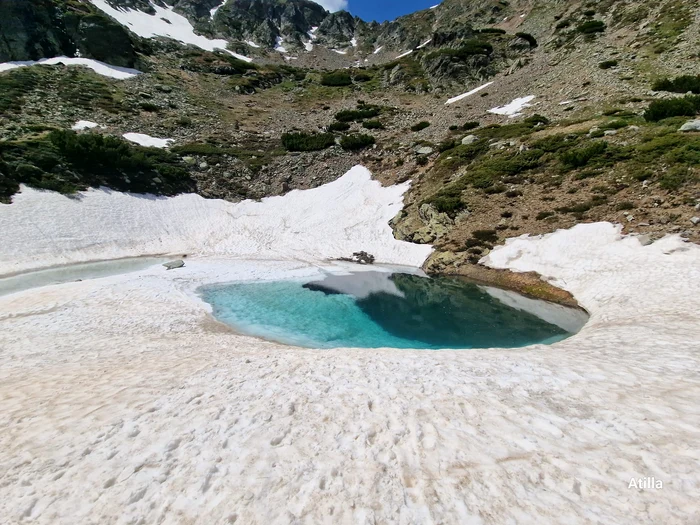
Glacial lake in the Parâng Mountains. Photo: Attila Dobai. Facebook
Like the Retezat Mountains in their vicinity, the Parâng Mountains have preserved numerous traces of the glaciations at high altitudes. The glacial cirques of Parâng are covered with scree, have steep and jagged ridges and thresholds that develop into waterfalls. The most developed are Roșiile, Cârja and Câlcescu.
At their bottom, travelers find at least 20 glacial lakes, the most famous being the Mija, Câlcescu, Roşiile and Iezerul Ingheţat lakes. Most of the glacial lakes in Parâng are located on the northern slope and are part of the hydrographic basins of Jietău and Câlcescu.
“Among the lakes belonging to the Jietului basin are the largest and most numerous lakes in the massif: Mija, Sliveiul, Roșiile and Dereșul (Ghereșul). The Câlcescu lake complex is poorer in number, but includes, instead, among them, the most beautiful glacial lake. Câlcescu Lake is at an altitude of 1,921 meters, being also one of the largest and deepest in the massif”show the authors of the monograph Parâng Mountains and Șureanu (1965).
One of the most demanding routes in the Pâarâng Mountains crosses the Câlcescu glacial caldera, where the most spectacular lakes of Parâng are located. The route starts from Cabana Parâng, in the direction Vârful Cârja – Vârfu Parângul Mare – Piatra Tăiată Saddle – Câlcescu Lake – Obârşia Lotrului. It has been marked with a red tape and can be completed in about 12 hours.
The paths to the heights of Parâng
The route crosses eight peaks of over 2,300 meters, reaches an altitude of 2,518 meters and then descends into the caldera of the Câlcescu glacial lake. But Parângul also offers its guests more accessible routes that cross equally attractive places.
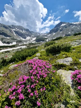
Image 1/9:
Parâng Mountains Photo Attila Dobai (10) jpg
Such a route passes through Cheile Jietului in Hunedoara (video), starting from Petroșani or Petrila, and then goes up to the Agățat refuge from Parâng, a picturesque stop at 1,700 meters altitude.
Located about 25 kilometers from Petrila and Petroșani, on the path used by many tourists to reach the peaks of over 2,300 meters and the glacial lakes of the massif, the Agățat refuge was built in the 80s, on a moraine – a huge boulder rolled over time with the melting of the Jietului glacier.
The tiny wooden cabin, set up on the six-meter-high cliff and surrounded by the forest of towering firs, offers its guests a spectacular view. Nearby, a waterfall adds to the charm of the mountain scenery. After the stop here, travelers can continue their way to the great heights of Parâng.
One of the routes leads to Parângul Mare, the second highest mountain peak in Romania. At its foot, the Roşiile hot spring, located at over 2,000 meters, offers a special view.
Beyond its charm and glacial lakes, in this land travelers also find some remains of aircraft that have crashed here over time.
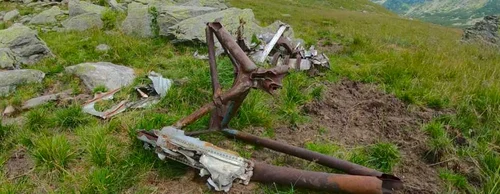
Image 1/7:
parang foro lucian ignat
“My attention was drawn to the numerous remnants of old aircraft, scattered on the alpine meadows: from quite large pieces of the skeleton of an old aircraft and fuselages, to small, metallic objects, some eaten by rust, which I could not identify. I was most captivated by the sight of an airplane rotor that I later learned crashed in the 60s – a real museum piece that watches over the caldera of the massif“, said photographer Lucian Ignat, from Hunedoara.
Climbing the ridges that dominate the great glacial cirques of Parâng, travelers discover an amazing panorama.
“From the heights of Parâng, at very deep evening hours, the land of Hunedoara appears cut by the ridges of the mountains and by strange valleys, grand and gloomy like an ocean floor, depository of Sarmizegetusa and Burdigalian (no historical period from 20 – 15 million ago of years), aware as if of the fabulous meaning of the riches he kept in his depths”recounted the writer Geo Bogza.
Transalpina, the road that climbs into the clouds
Tourists who want to explore the Parâng Mountains can do it both on the difficult mountain trails due to their length, but also on some mountain roads.
The most famous of them, Transalpina (National Road 67C), reaches an altitude of over 2,000 meters, being the road that reaches the highest heights in Romania.
For almost a century, Transalipna has been used as a connecting road between the lands of Sibiu and southern Romania.
Over time it became a modern road, sought after by more and more travelers. DN 67C crosses the Parâng Mountains, from Novaci (Gorj) to Sebeş (Alba), for a length of almost 148 kilometers. The most spectacular sector passes through the Urdele Pass in the Parâng Mountains, at almost 2,145 meters.
Until the beginning of the 20th century, the mountain road through the Urdele pass, extremely difficult and dangerous, was used only by shepherds in transhumance and less by military troops trained on the mountain.
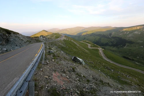
Image 1/32:
Transalpina Photo Daniel Guță THE TRUTH (181) JPG
The paths that connected the region of Sibiu with the one south of the Carpathians were transformed into a mountain in the 1930s, with the establishment of the first cabins in Rânca. King Carol II inaugurated the start of the modernization works of the Transalpina ridge route, which led to the new tourist complex.
In the following decades, the Transalpina gained its name as the King’s Road, and it was most often used by shepherds from the Sibiu region and by hunters.
Transalpina was completely asphalted only at the end of the 2000s, but the modernization works of the mountain road are not completed in some sections. Although it remains open only a few months a year, it is increasingly sought after by travel enthusiasts.
The Jiului gorge – the pass in the Carpathians
Some of the valleys at the foot of Parâng are also crossed by spectacular roads. Modernized in recent years, the National Road 66 that crosses the Jiului Gorge has become one of the most attractive routes in Romania.
The Jiului gorge starts at the edge of the Petroșani municipality in Hunedoara, where the waters have made their way through the deep valley of the mountains and continues along a winding route of more than 30 kilometers to the south of Romania, until the entrance to the town of Bumbești Jiu, in Gorj county.
Over time, the Jiului Gorge represented a vital communication route for the inhabitants on one side and the other of the Carpathian Mountains, in Transylvania and the lands of Oltenia, even if the road through the mountains was often extremely dangerous. Over the past two centuries, people have made great efforts to “tame” the forces of nature in the Jiului Gorge.
The roadside rocks following the course of the Jiu have been chiselled and blasted, and the slopes cemented, tunnelled and netted in countless places to lessen the danger of rockfalls and make way for the road and railway.
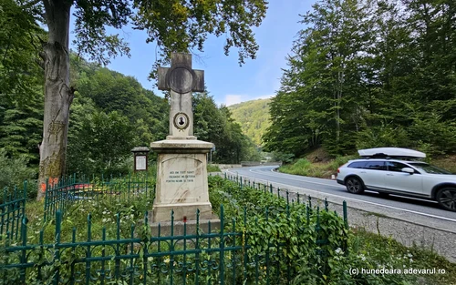
Image 1/25:
Jiului Gorge Photo Daniel Guță THE TRUTH (13) JPG
Falling boulders and trees, some from almost 200 meters above the road, continued to occur frequently and cause casualties – the most recent in autumn 2022 – and the risk of accidents could not be completely removed.
Over the past five years, the Jiului Gorge upgrade works on National Road 66 have reconfigured the spectacular mountain route and made it more accessible and safer.
Bridges and footbridges were rehabilitated, slopes were reinforced with steel nets in vulnerable areas, metal parapets were installed along the entire length of the road to reduce the risk of cars ending up in the river, some curve areas were widened after the builders had to dynamite portions of the mountains, new bridges were built, abandoning some unsafe constructions.
The Jiului Gorge road has become more attractive for tourists, and in addition to its spectacular route through the mountains, it also offers travelers some historical landmarks.
The most sought-after place on the Jiului Gorge is the Lainici Monastery in Hunedoara, built and painted two centuries ago, currently one of the few human settlements on the route in the mountains.
Parâng mountain resort
The place where the busiest paths to the heights of Parâng start is the Parâng mountain resort, established in the 70s, ten kilometers from Petroșani and Petrila.
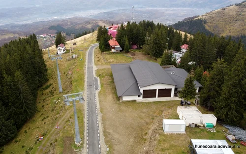
Image 1/18:
Parang mountain resort Photo Daniel Guță THE TRUTH (37) JPG
It was then that the first tourist cabins in Parâng were built, as well as the resort’s old chairlift, which went up to the alpine area, at the IEFS sports complex, located at an altitude of 1,740 meters.
The number of cabins in the Parâng tourist area currently exceeds 200, and the row of constructions has expanded around the old athletes’ cabin, on the edge of the ski slopes with a total length of over eight kilometers.
A road modernized in recent years connects the area at the foot of Parâng with the resort, but tourists can also go up here by chairlift.
From the resort, travelers can climb to the Parângul ridges on the route that crosses Vârful Parângul Mic (2,074 meters), Refugiul Cârja – Vârful Cârja (2,405 meters), Vârful Gemănarea (2,426 meters) and Vârful Parângul Mare (2,519 meters).