
Hidden in the Orăștiei Mountains, just a few hundred meters from Via Transilvanica, the Pustiosu sanctuary has remained a place full of mysteries. Its terraces, strewn with massive andesite blocks, and the ruins of a supposed temple have intrigued archaeologists and treasure hunters.
Via Transilvanica crosses Romania, from Bucovina to the Danube, on a route of more than 1,400 kilometers, which connects some of the most picturesque places in the Carpathians.
Via Transilvanica, offering attractive places
In Hunedoara, a 150-kilometer segment of the hiking route, inaugurated in 2022 under the name Terra Dacica, passes through the Natural Park Grădiștea Muncelului – Cioclovina (Șureanu Mountains) and at the foot of the Retezat. Travelers get off from here at Ulpia Traiana Sarmizegetusa and leave the county and Terra Dacica at the Iron Gates of Transylvania, the pass between Transylvania and Banatul Montan, respectively between Hunedoara and Caraș-Severin.
In Hunedoara, Via Transilvanica shows hikers a lot of attractive places: the pastoral villages of the Șureanu Mountains (Măgureni and Târsa), the places of stables and archaic settlements (Poiana Omului, Fundătura Ponorului), the wild valleys of the mountain streams (Sibișel, Grădiștea, Ponor), the mountain plateaus inhabited since ancient times (Luncani, Vârtoape), the land of Dacian fortresses (Sarmizegetusa Regia, Costești, Blidaru) and the oldest Roman settlements (Ulpia Traiana Sarmizegetusa). A separate segment of the route connects the Grădiști Valley – the place where the most spectacular Dacian settlements in Romania were lined up – with the Luncanilor Plateau.
At Grădiștea de Munte, after the travelers leave the Grădiști Valley, leaving behind the Costești – Sarmizegetusa Regia road to climb through the forest to the pastoral village of Târsa, they pass a few hundred meters from one of the mysterious places of the land of Dacian fortresses.
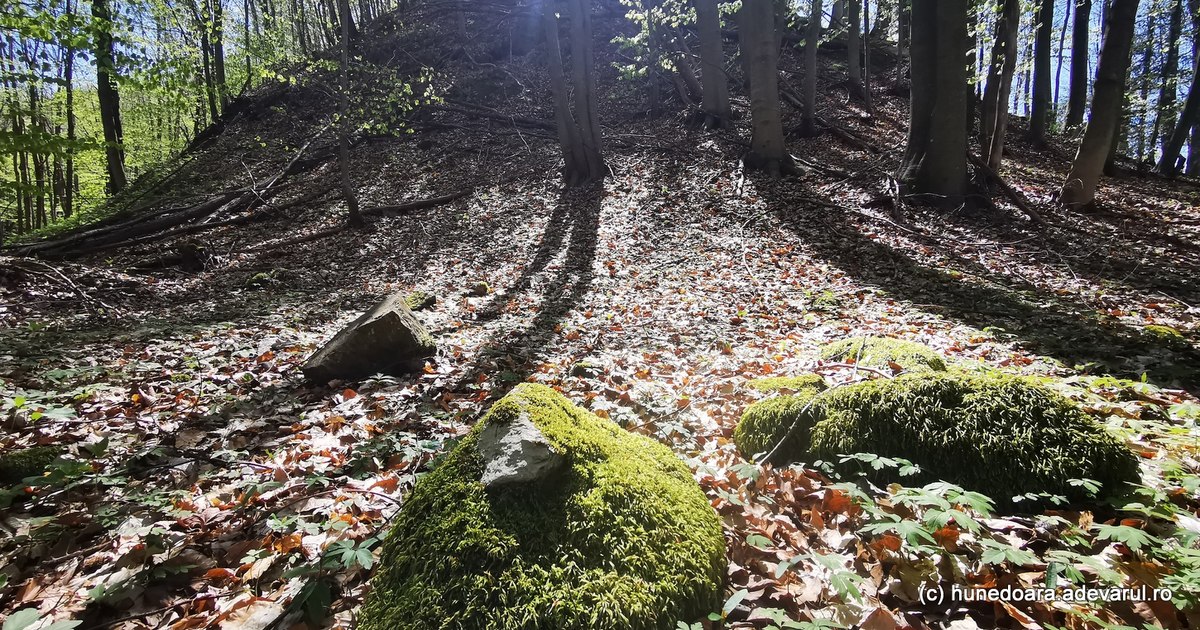
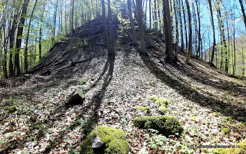
Desolate Hill
An unmarked path goes up, from the local forestry bypass, to the left of the forest road, towards the Dacian settlement on the Desolate Hill in Hunedoara, about 20 minutes’ walk away, on a route almost parallel to Via Transilvanica, but which follows a supposed Dacian road. The old path climbs more and more towards the crest of the hill, leaving lower and lower the deep valley of the Pustiosu stream (Apa Mică), used by tourists.
Near the top of the hill, covered by forest, the terraces of the former Dacian settlement and the remains of a large building with an apse, identified by historians as a sanctuary, can be identified.
The Dacian settlement was discovered in the 1950s by archaeologists led by Constantin Daicoviciu, and since then scientists have not researched it. Instead, in the 1990s and 2000s, the ruins of its edifices were scoured by treasure hunters.
“On the left side of the Grădiștei River, before it joins the Anineș Valley, rises a wooded hill with tall beech trees, known by the locals as Pustiosu. This hill stretches in the SW direction, along the Grădiștei River, starting from the confluence of this valley with the Apa Mică, deciding to the SW the village of Grădiștea Muncelului from the village of Luncani. Despite the name that this hill now bears, with steep ravines, it is full of trees, forming a thick forest of tall, not very old beeches. None of the locals remember this hill bearing such a curious name and inappropriate to the situation of the place”noted the archaeologists Constantin Daicoviciu, Nicolae Gostar and Ion Horațiu Crișan, in the report of the researches from Pustiosu, from 1955.
In the 1950s, archaeologists followed a route similar to today’s path to the Dacian settlement. They started from the brigadier’s house, located at the confluence of Apa Mici and Apa Grădiștei, followed the forest road up the valley for about 150 meters, then entered a path that went up one of the slopes of the Desolate Hill.
From here, they continued down a gentle slope, following what the researchers identified as an ancient road, laid out on the hilltops and slightly sunken into the ground by long use. Along this route they noticed several terraces, and after about 15–20 minutes of walking they reached a wider terrace, near which the ancient road forks, with a branch to the north and another to the west.
The terrace that attracted their attention stretched over almost a hectare, having a semicircular shape, with the top in the northern direction, and in the southern part it rested on the foot of a high and precipitous hill. To the north were the ancient road and the forest that went down to the valley of Apei Grădiștei.
The mysterious construction from Pustiosu
More than 100 tall trees occupied the terrace in front of the spur on the Desolate Hill, so scientists had difficulty surveying the settlement.
However, since the first days of the excavations, they discovered numerous blocks of ancient stone, limestone and andesite, used in some constructions, ceramics, iron objects and some mounds that indicated traces of ancient buildings. The most important discovery was the ruins of a circular building, inside which there was a circular room, and inside that, another rectangular room and an ancient hearth.
Why did the Dacians build a lot of temples. Unknown sanctuaries come to light and intrigue scientists
“By two entrances one entered a wide, round corridor, whence, by four other entrances, one came into a space also round in shape with walls of whitewashed adobe. The light entered here through clerestory windows set somewhere high in the wall, for this wall was quite thick and consequently much higher than the wall of the outer circle. The last opening, with a hearth in the middle, was probably the most luxurious room of this grand Dacian edifice. The light most likely came from the west, through an opening fixed in the wall of the second circle”archaeologists noted.
This type of edifice with an apse has also been identified in other Dacian settlements, the best known being those at Sarmizegetusa Regia, Fețele Albe and Piatra Roșie. Some archaeologists have described them as buildings with a religious or meeting role of the Dacian chiefs. Other similar constructions, circular in shape, discovered in the mountains around Sarmizegetusa Regia (Rudele, Tâmpu and Maleia), were presented by some historians as pastoral dwellings or of workers from ancient mining operations.
“These dwellings, which probably derive from that primitive tugurium (no hut), were much appreciated, due to the elegance and roundness of the line, by the Dacian architects. From the Roman relief we deduce that the entrance was decorated with carved wood ornaments”, pointed out the historian Constantin Daicoviciu.
Archaeologists have established that the settlement on Dealul Pustiosu dates from the 1st century BC. BC And it would have been destroyed by fire. Another construction erected in its place was also devastated by the fire. During the communist period, tourists rarely reached the settlement on the Desolate Hill.
The mysteries of the andesite stones from Pustiosu
After 1990, the Pustiosu sanctuary was most often explored by treasure hunters, who rummaged through its walls.
The scientist and publicist Andrei Vârtic (1948–2009) from the Republic of Moldova, known especially for his concerns related to the ancient history of the Carpatho-Danubian region, also arrived here. He vividly described the settlement, amazed by the large number of andesite rocks on its terraces and the way it was terraced on the northern, shaded side of the slope.
“Pustiosu comes next, a mountain with andesite sanctuaries. The stone with the dimensions of 432×360×180 = 27,993,600 cubic cm, which I have talked about elsewhere, lies here in respectable quantities on a colossal terrace, rounded on the ridge of the mountain, also guarded by a kind of earthen construction like those on Comărnicelu Cetății and Sub Cununi. Why did he need these eternal stones, the andesites? Why did he have to cut them from the rock, following the line of the magnetic field during solidification, to shape them, to bring them from great distances and put them in certain places without utilitarian meanings? made of clay and adobe?)”, note this one.
Nearby were the uranium mines of Gerosu
Near Pustiosu, in another deep valley, at Gerosu, the forest hides the remains of abandoned uranium mines from the 1990s. Geological explorations in the Orăștiei Mountains would have taken place since the 1940s.
The healing plant hidden in the Dacian fortresses. Why was it called bear’s garlic?
“The first investigations regarding the presence of uranium in the area were carried out by the Germans, around 1942-1943, those Germans who helped Constantin Daicoviciu to make the excavations at the Cetate (no. Sarmizegetusa Regia). The mine they started can still be seen now, it is called, with the humor characteristic of Romanians, Gaura Neamţului, and it is located a little above the village, on the right bank of the water (no. Kindergarten)”, recounted Cornelius Ionescu, a good connoisseur of the area.
In the early years of communism, when the exploitation of Romania’s natural resources was largely controlled by the Soviets, the rush for rare metals continued in the Orăștiei Mountains, up to the vicinity of Sarmizegetusa Regia, but the discovered deposits were not considered viable.
“During the Soviet occupation and until 1980, excavations were still made, but only for prospecting, not for exploitation. The mines on the left side of Grădišta, on Valea Gerosu, Valea Larga, were made by the Russians for the exploitation of uranium. The mines were, in fact, abandoned after 1989, leaving their closure to time.” says Cornelius Ionescu.
In the 1990s and 2000s, some locals complained that the places where the remains of the mines were still visible had not been greened. However, the Hunedoara Environmental Guard announced that the former mining perimeters did not present a high level of radiation, so as to endanger people’s health. Andrei Vârtic had also explored Gerosu, a hill now covered by vast forests.
“Right next to Pustiosu, walking in a circle to the South, you touch with your hand (from Dealul Muncelului, elevation 765), Mount Gerosu, the one with the modern uranium mines in it. We also passed it with the radiometer in hand, its heart (of the radiometer) beating like the heart of an old rabbit chased by a young fox. These uranium mines have been industrially dug for years. What was taken from them with the tipper, with the railway wagon taken away is (a few years ago a small train used to go up the Grădisti Valley, the line of which was dismantled in a few days after the closure of the operation, a small train that was incredibly necessary for the locals too – today they no longer have anything to take the products of their work as sheep and cattle farmers to the City)”recounted the publicist in the volume “The Road to Kogaionon”.
According to the report “Romania’s Strategy for Non-Energetic Mineral Resources horizon 2035”, in the Grădiștea de Munte area there are reserves of Niobium and Tantalum, but also of rare earths – a group of 17 essential chemical elements in the manufacture of high-tech products.
In recent years, the settlement on Dealul Pustiosu continued to remain hidden from travelers, despite its proximity to Via Transilvanica, only a few hundred meters away.