
The Carpathian Mountains are studded with ruins of some Dacian settlements, but the most spectacular such monuments are in Hunedoara. They have been declared UNESCO sites and are visited annually by tens of thousands of tourists.
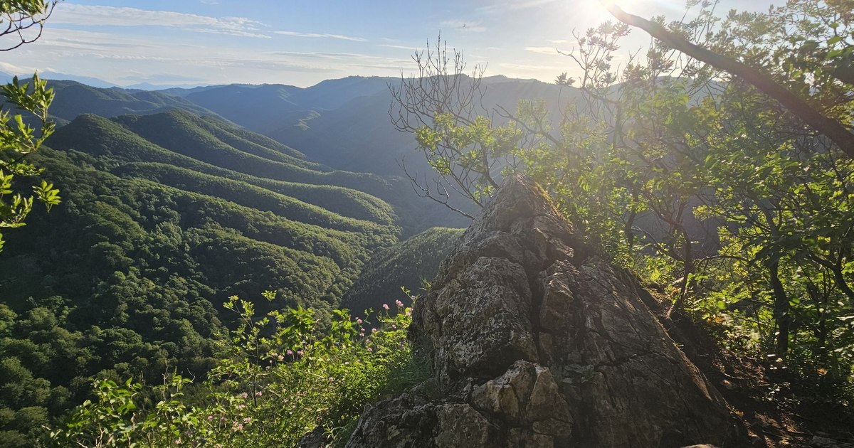
The view from Piatra Roșie, Hunedoara. Photo: Daniel Guță. TRUTH
While most of the Dacian era sites are difficult for tourists to “decipher” without the guidance of specialists, some of the Dacian fortresses in the Orăștiei Mountains (video) have preserved, among the Dacian settlements in Romania, the remains of some attractive monuments, which offer visitors the chance to understand more about the past.
Sarmizegetusa Regia, the Stonehenge of the Dacians
Located at the foot of Vârful Godeanu (1,656 meters), considered “the holy mountain of the Dacians” and about 40 kilometers from the municipality of Orăștie. Sarmizegetusa Regia was considered by historians to be the capital of the Dacian Kingdom, before it was conquered and devastated by the Romans at the beginning of the second century.
Because of its mysterious edifices, it has often been compared to the Neolithic Stonehenge in England, considered a monument dedicated to solar deities, where religious ceremonies and celestial observations may have taken place
In Antiquity, the citadel spread over more than a hundred terraces arranged by people. The most important were in the sacred precinct, which included the most important buildings of the Dacian capital.
Image 1/8:
Sarmizegetusa Regia, Photo Sarmizegetusa Regia Administration (6) jpg
The strong walls that protected the large terraces of Sarmizegetusa Regia (IX, X, XI) were meant to prevent them from sliding. Other smaller walls, built in the murus Dacicus technique, protected the sacred precinct of the Dacian capital from the hill and sides.
“The stepped arrangement of the three terraces, enclosed by their strong and imposing white limestone walls, must have been impressive, recalling, while preserving the proportions, the image of ancient Pergamum“, pointed out archaeologist Ioan Glodariu (1940 – 2017).
Tourists find here the ruins of temples and several ancient edifices, water catchment installations, but also the walls and gates of a strong fortress and the ancient stone road that descended into the sacred precincts of Sarmizegetusa Regia.
How to get to Sarmizegetusa Regia
An 18-kilometer road, modernized a decade ago, goes up from the village of Costești in Hunedoara, on Valea Grădisti, to the parking lot located about one kilometer from the ancient gates of Sarmizegetusa Regia.
From the parking lot, tourists can continue their way to the site on foot, walking along the path paved with cubic stone.
The village of Costești in Hunedoara is located about 20 kilometers from Orăștie, on county road 705A and about 20 kilometers from the city of Călan, on county road 668A Călan – Boșorod, connected over the hills by the local road Chitid – Ludeștii de jos – Costești. Another local road, also asphalted, towards the village of Costești, descends from the village of Târsa in the commune of Boșorod.
The palaces of the Dacian kings from Costești
The Dacian fortress from Costesti (video) was built during the time of King Burebista, in the 1st century BC. AD, and served as a military fort, but also as a civilian settlement. Like the other Dacian fortresses, it was devastated during the wars of conquest of Dacia by the Romans (101 – 106).
The ruins of several imposing buildings have been preserved here: two towers – housing, bastions, four sanctuaries, water cisterns, fortification walls.
The most famous monuments in Costeşti are the two towers, located about 100 meters from each other on the top of the hill. The “palaces” built in the middle of the 1st century BC. BC. They were used as residences for the Dacian chieftains. They have sides of at least 12.5 meters, walls up to three meters thick and were built from limestone blocks, then continued vertically with a wall of burnt bricks, with massive burnt clay tiles used for the roof, archaeologists say .Access to the first tower was made on a monumental stone staircase, still preserved today.
“The tower represented the residence of a high-ranking personage, probably the lord of the fortress, and, together with the other construction erected at the opposite end of the plateau, could be the last point of resistance in case of a siege”the archaeologists pointed out.
How to get to the Dacian fortress of Costești
The last three kilometers of the road to the Costești fortress start from the bridge over the Apa Grădisti river in the village of Costești.
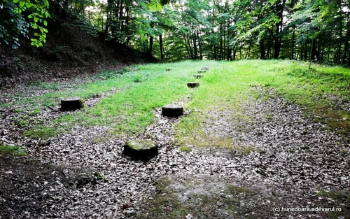
Image 1/7:
the Dacian fortress costesti photo daniel gutta the truth
They are practicable with cars, but they are not modernized, and due to the limited spaces for parking, it is recommended to leave the cars in the area of the bridge in the village of Costești, or at the foot of the hill. From the end of the road, in front of a household in the village, tourists have to walk about ten minutes to the entrance to the Dacian citadel.
The Dacian bastion from Blidaru
The Dacian fortress of Blidaru was built in the 1st century BC on a hill that rises above the valley of Grădisti in Hunedoara. It had a trapezoidal shape, walls in the murus dacicus technique, with thicknesses of up to three meters and heights that reached five meters in Antiquity, and included six strong defense towers, an inner tower and eight casemates.
The entrance to the fortress was initially made only through one of the towers, made in the “a chicane” system. If the invaders destroyed its wooden gate, they hit the back wall of the tower, being then forced to turn to the right, towards another gate, making their progress difficult. A second entrance to the fortress, also flanked by two walls, was built later.
According to archaeologists, the “casemates” sheltered behind the walls were not found in other Dacian fortresses. The Dacians’ fighting machines would have been placed on them, which could throw the projects into the valley, up to 300 meters, to prevent the approach of the enemies.
Several civil settlements were discovered around the Blidaru fortress, on terraces made in steps, connected to each other by road networks, and nearby, in the place called Pietroasa lui Solomon, there was a sacred area with several temples.
Civilian settlements were defended by several towers, apparently solitary. The most spectacular and well-preserved of them is located in the place called Poiana Perţii and would have been used for the defense of the fortress and one of its water cisterns.
How to get to the Dacian fortress Blidaru
The path to the Dacian fortress of Blidaru starts from the area of the bridge over Apa Grădisti in the village of Costești in Hunedoara, on a route of about two kilometers, which represents an almost continuous climb through the forest.
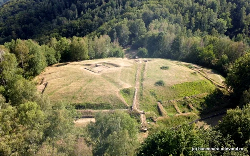
Image 1/8:
the Dacian citadel of Blidaru photo daniel guta the truth
Hikers are advised to take water supplies with them and wear hiking shoes. From Costești to Blidaru, tourists usually take 40 – 60 minutes. Travelers can reach the Blidaru Dacian Fortress starting from the center of Târsa village in Hunedoara, in the area of the old school and village church, on an unmodernized dirt road, continued with a marked path. The distance from the village to the fortress is about five kilometers.
Dacian steps from Piatra Roșie
The Dacian fortress Piatra Roșie was built in the 1st century BC. BC and lasted until the Daco-Roman wars at the beginning of the second century.
It was rediscovered at the beginning of the 19th century by the locals, seized by the fever of ancient treasures hidden in the mountains, and intensively researched by archaeologists coordinated by Constantin Daicoviciu, in the middle of the last century.
Archaeological excavations have revealed the paved road, ancient walls and towers, but also the ruins of a mysterious edifice, a supposed ancient temple, as well as some precious artifacts, such as the bronze bust of a female deity and fragments of an ancient iron disk. In the 2000s, treasure hunters found other iron discs here, richly ornamented with floral and animal motifs, which could have served as cult objects or to show the prestige of the owners of the fortress.
Recently, the settlement was researched, for the first time, with the help of LIDAR, laser scanning and mapping technology, and the conclusions, presented by the researcher Aurora Pețan, were that it was much larger in Antiquity, it had not only a military role and also included the hills from the surroundings on which there are several unexplored terraces, but which preserve ancient traces of habitation.
How to get to Piatra Roșie Dacian Fortress
The main access road to the Dacian fortress of Piatra Roșie, located about 20 kilometers from the town of Călan in Hunedoara, is the Călan – Boșorod – Valea Luncanilor road (DJ 668 A). The road that crosses the Luncanilor valley is one of the access roads to the Grădiștea Muncelului Cioclovina Natural Park.
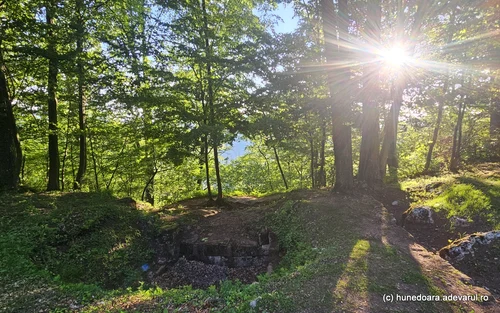
Image 1/12:
Dacian citadel Piatra Roșie Photo Daniel Guță THE TRUTH (13) jpg
It is modernized along most of the route. At the exit from the village of Luncani, the road plunges into the wilderness going up towards the Cioclovina Cave in Hunedoara. Tourists who want to reach the Dacian citadel of Piatar Roșie turn left, going up a local paved road of about three kilometers to the foot of the citadel. From here, they still have to go about 500 meters, on a mountain path, which climbs steeply to the peak occupied in the past by the fortress.
White Faces Fortress,
The Dacian fortress Fețele Albe (video) is located 3-4 kilometers from Sarmizegetusa Regia, in the middle of the forest that covers Sesul cu Brânza, the slope neighboring Grădisti Muncelului on which the Dacians built their capital during the years of King Decebal.
In the early 1970s, archaeologists made the first excavations at the Dacian fortress Fețele Albe and revealed the remains of several dwellings and temples, arranged on terraces reinforced with massive limestone walls.
“The complex of walls on the terrace gives the impression of a large, flourishing settlement, for the arrangement of which many efforts were made“, archaeologists Hadrian Daicoviciu and Ioan Glodariu pointed out in 1969.
Treasure hunters have rummaged in the Dacian fortress of Fețele Albe in recent decades, they have caused destruction, but they have not been able to bring about major changes to the current appearance of the archaeological site. Instead, nature has completely transformed the appearance of the monuments.
Scientists who have recently studied it, also using LIDAR, laser scanning and mapping technology, have made a number of amazing discoveries here. Although the ancient settlement was thought to consist of 20-30 terraces, the use of LIDAR technology showed that the White Faces were much more extensive. The fortress occupied an entire mountain, now completely covered by forest, and is older than Sarmizegetusa Regia.
How we get to the White Faces
The Fețele Albe fortress is located on a hill adjacent to Grădisti Muncelului, on which Sarmizegetusa Regia was built. For the most part, the route followed by tourists overlaps with the road to the Dacian capital.
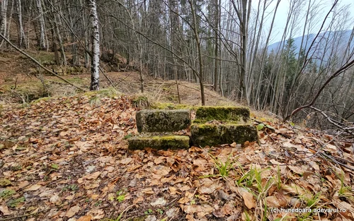
Image 1/17:
Dacian citadel White Faces Photo Daniel Guță THE TRUTH (76) jpg
The routes to the two ancient settlements diverge on the Albă valley, about three kilometers below Sarmizegetusa Regia.
Here, from a small parking lot on the side of the road, travelers climb steeply up the hill to the left of the water, on the path that winds through the forest, to the ruins of the White Faces. The walking route to the site can be completed in about 30-40 minutes.