
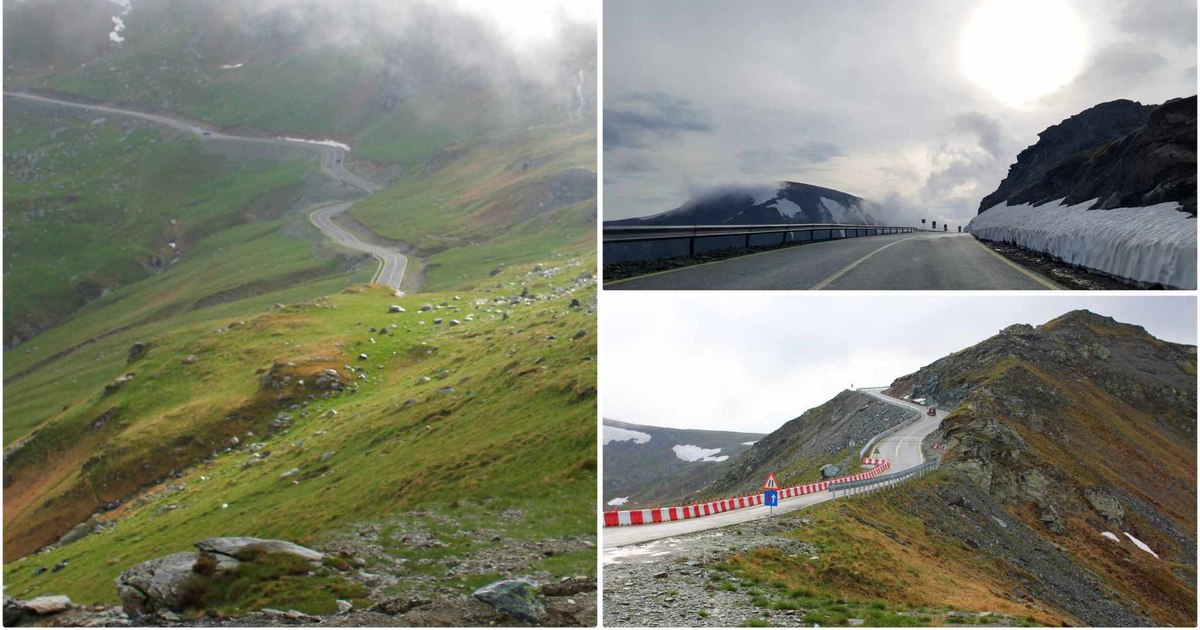
After almost eight months after the closure of its alpine sector, Transalpina, the highest road in Romania, has been reopened to traffic and will be accessible by car during the summer. National Road 67C crosses one of the most spectacular mountain areas in Romania.
Car traffic on the mountain sector of the National Road 67C, also known as the Transalpina, was reopened on Friday after the road had been closed to traffic since the beginning of October 2025 due to weather conditions and risks to the safety of travelers.
Transalpina, accessible during the summer
On the alpine sector of the road that crosses the Parâng Mountains, complex interventions were necessary, because the layer of snow deposited and brought by the blizzard reached, in some places, several meters. In addition, rockfalls and areas at risk of freezing were endangering traffic safety.
The snow removal and repair works were completed, and on Friday, May 29, following the verification and reception of the road sector by a commission of the National Road Infrastructure Administration Company (CNAIR) and the regional directorates of Craiova and Cluj, the Transalpina became passable again along its entire length, of approximately 148 kilometers, between Novaci (Gorj county) and Sebeș (Alba county).
The alpine sector reopened to traffic is 44.4 kilometers long and is between Rânca and Curpăt, from kilometer 34+800 to kilometer 79+200. In Pasul Urdele, the road reaches the maximum altitude of 2,145 meters, the highest reached by a road in Romania.
“Road traffic will be allowed for vehicles with a maximum authorized mass of up to 3.5 tons, as follows: between May 29 and June 30, 2026, traffic will be allowed between 09:00 and 20:00; between July 1 and August 31, 2026, traffic will be allowed between 07:00 and 21:00. Participants in traffic are obliged to comply with the established road signs and traffic restrictions on this mountain road sector. Depending on the weather conditions, road traffic may be temporarily restricted or closed for the safety of road users”. informed DRDP Craiova.
The regional directorate advises drivers to drive with caution, adjust their speed to the road conditions and constantly inform themselves about the state of the roads before setting out on the road.
Transalpina, the tourist attraction accessible only during the summer
The Transalpina (DN 67C), also known as the “King’s Road”, connects, on a route of almost 150 kilometers, the lands of Sibiu with the south of Romania. In its most difficult segment, of more than 40 kilometers, it crosses the Parâng Mountains, winding along ridges that exceed the altitude of 2,000 meters.
The alpine area, accessible during the summer, starts from Valea Lotrului, near Obârsia Lotrului, a place located in a wild mountain region, at the meeting of Hunedoara, Sibiu, Alba, Vâlcea and Gorj counties, at the foot of the Parâng, Șureanu and Latoriței massifs.
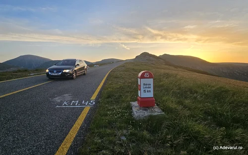
From Valea Lotrului, the route climbs in serpentines towards the Rânca resort, through conifer forests and alpine meadows. Here travelers are presented with the wide panorama of the Parâng, Lotrului, Cindrel and Șureanu Mountains, with peaks of over 2,000 meters, caldera and glacial valleys shaped by glaciations. The glacial lakes of Parâng, more distant, remain hidden from view. Instead, old sheepfolds, established in remote clearings, surrounded by forests, and more modern ones, close to the road and transformed into rest stops, adorn the slopes.
The road to the old Rânca resort from Parâng
Outside the Rânca mountain resort, established in the 1930s, the landscape of the area is wild, little affected by human interventions. The road is inaccessible for more than half of the year, so human activity and construction is reduced.
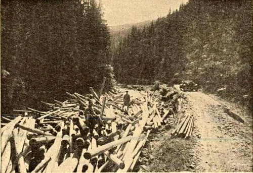
Before the construction of the alpine road, the road through the Urdele pass was used only by shepherds in transhumance and sometimes by military troops trained on the mountain. In the summer of 1935, King Carol II and his son, Michael I of Romania, were among the distinguished guests who inaugurated the Transalpina, traveling by car from Săliște (near Sebeș) to Novaci (Gorj). It was also then that the first cabin from Rânca was opened.
Lake Oașa, the “pearl” on the Transalpina. Sadoveanu’s corner of heaven, hidden in the heart of the Șureanu Mountains
For a long time, the unpaved road from Obârsia Lotrului to the ridges continued to be extremely difficult to travel, due to steep slopes, difficult curves, bordered by cliffs, and sharp stones in the roadway. It was most often used by shepherds from the regions of Sibiu and Oltenia, by hunters and adventurers who wanted to reach the Rânca resort and the ridges or the glacial lakes of Parâng.
Transalpina was completely asphalted only at the end of the 2000s, but the modernization works of the mountain road are not completed on some sections. Although it remains open only a few months a year, it is increasingly sought after by travel enthusiasts.
Otter Lake, the pearl of the Lotru Mountains
One of the oldest tourist areas accessible from the mountain road is at Rânca, on the ridges of Parâng. In recent decades, numerous cabins and guesthouses have been built here, at over 1,600 meters above sea level. During the winter, tourists can ski on several slopes arranged on the Corneșu and Păpușa mountains, at altitudes between approximately 1,600 and 1,900 meters, some equipped with ski lifts, chairlifts, nocturnal and installations for the production of artificial snow.
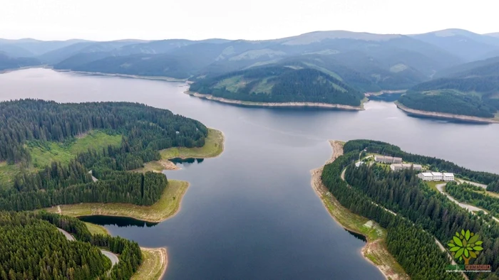
In the 70s, another tourist area developed about 30 kilometers from Rânca, around the Vidra reservoir, set up in the Lotru Mountains with the construction of the Lotru-Ciunget hydropower system. The Vidra Dam, built of rock with a central clay core, is 121 meters high and 350 meters long at the crest. The dam is almost 1,300 meters above sea level, being the highest dam in Romania. The reservoir can store over 300 million cubic meters of water. The water collected in the Vidra lake is used by the underground Lotru-Ciunget hydropower plant, with an installed power of 510 MW, through a gross water fall of 809 meters.

Near Lake Vidra, tourists find the Transalpina Ski Resort, located in the Obârsia Lotrului area, approximately 34 kilometers from Voineasa.
Lake Oașa, at the foot of Șurean
Another attractive area on the route is the Oașa lake, located on the Sebeș River, in the Șureanu Mountains. The lake is at an altitude of 1,255 meters, has a volume of 136 million cubic meters and an area of 454 hectares. The Oașa Dam, built of rock, has a height of 91 meters.
How to drive on the Transalpina 90 years ago: “It turns endlessly and with every step you hit the edge of a bottomless void”
In the past, the place upstream of the dam was known as Valea Frumoasei, a land that would have inspired the writer Mihail Sadoveanu in the volumes “Valea Frumoasei” (1938) and “Poveștile de la Bradu’ Strâmb” (1941). The Oașa Monastery can be visited near the lake. Its wooden church, built in 1943, was moved in the 1980s, with the construction of the reservoir.
The road to the Șureanu Ski Area starts from the Oașa dam area, as well as several mountain trails to the crests of the Șureanu and Cindrel Mountains. Nearby there are traces of Roman marching camps, used by the troops that advanced towards Sarmizegetusa Regia during the Dacian wars.

Three such temporary fortifications have been identified on the Comărnicel peak, and another Roman fort is located on the saddle between Pătru Peak (2,133 meters), which dominates the panorama of Lake Oașa, and Aușel Peak (2,009 meters).