
Inhabited since ancient times and remaining isolated for a long time, several villages in Romania have become attractions for lovers of mountain excursions. Some have been established at over 1,300 meters altitude and are sought after for their picturesque views.
The “highest” archaic villages in Romania, established at over 1,000 meters above sea level, on the peaks of the Carpathians, began their existence as pastoral settlements or as places of refuge for Romanians and their ancestors.
Some were landmarks of the old borders between the historical regions of Romania, separated by mountains, and others owed their existence to the exploitation of centuries-old forests, exploited in the past by the locals. Mining resources also played an important role in the development of some alpine settlements, but herding and transhumance were the activities around which the life of these communities was centered.
Over time, many of the “mountain brain” settlements depopulated, while others fared better due to their accessibility and tourism potential.
Founded, one of the first tourist villages
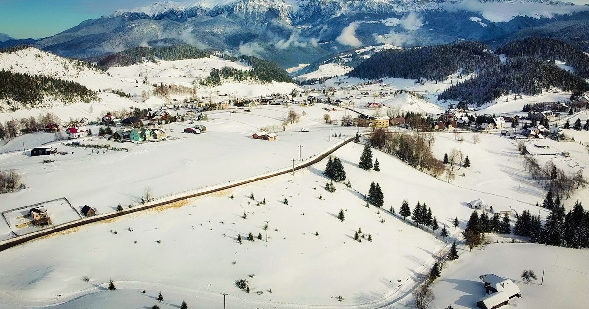
Located at over 1,300 meters above sea level, the villages of Fundata, Fundătica and Şirnea, of the Fundata commune (Brașov county), became landmarks of rural tourism in the 70s, when the settlement located on the Rucăr-Bran corridor, at the foot of the Bucegi and Piatra Craiului mountains, became a tourist village.
In 1973, by an order (744/1973) of the Ministry of Tourism, intended to organize rural tourism, the localities: Hălmagiu (Arad county), Rucăr și Lerești (Argeș county), Fundata-Șirnea (Brașov county), Tismana (Gorj county), Rășinari (Sibiu county), Vatra Moldoviței (Sibiu county) were declared tourist villages Suceava), Murighiol and Sfântu Gheorghe (Tulcea county) and Vaideeni (Vâlcea county).
The commune of Fundata, with less than 700 inhabitants, is located approximately 20 kilometers from the old customs point Rucăr and another 20 kilometers from the town of Bran, famous for its castle.
The medieval castle became popular in the 20th century, being sought after by numerous Romanian and foreign travelers, attracted by the legends of the famous “Dracula”, who supposedly ruled the fortress, and by the picturesque places in its surroundings. Before becoming well-known tourist destinations beyond Romania’s borders, the alpine villages on the Rucăr-Bran corridor developed thanks to the vast forests in the region. Fundata is also remembered as a border between the historical regions of Transylvania and Muntenia.
“Fundata was located right on the border between the Austro-Hungarian Empire and Wallachia, and the people had come to have their house in one country and their stable in another. Several times a day, they crossed the border to feed their animals. Fundata was the first town liberated by the Romanian military troops. Thus, during the battles for Fundata, on August 14, 1916, colonel Gheorghe Poenaru-Bordea (deputy commander of the 30th Infantry Regiment “Muscel”) crossed the border with his troops and was killed. He was the first Romanian to fall in the First World War. Several dozen other soldiers died in the battles for the liberation of Fundata”the history of the locality shows.
At the beginning of the 70s, the settlement had about 1,300 inhabitants, but during the summer the number of people doubled due to tourists. The people of Fundata and the neighboring hamlet of Şirnea were engaged in forestry work and animal husbandry, but tourism gradually changed their way of life, with more than 40 rooms being made available to travelers who came to explore the beauties of the Piatra Craiului National Park.
“In the summer, you can gather sedum, chamomile, St. John’s wort, mouse tail, with which the people and cattle of Fundata medicate themselves. Or do a dairy cure at the many herds around. Apart from the mountains, Fundata also has two caves and a bottomless lake in the forest.” informs the magazine Romania picturesque.
The village between the clouds, hidden in the heart of the Apuseni
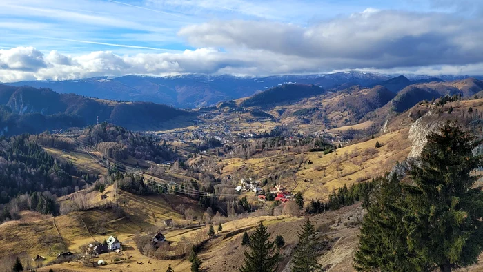
Located in western Romania, the Poiana Ruscă Mountains are a distinct mountain region, located between the Apuseni and the Southern Carpathians. The highest peaks, Padeșul and Rusca, do not exceed 1,400 meters, but their surroundings have been inhabited since Antiquity. In the 2nd century, the “rustic” land near Sarmizegetusa had become an important mining district of the Roman province of Dacia.
The first villages of the foresters, as the native population of the region is called, are attested from the medieval period, being linked to the rich iron resources and the forestry operations around which they developed.
Several forester villages were established at over 1,000 meters altitude. The “highest” of them, Vadu Dobrii, inhabited today by only a few families, had become an important locality for the economy of the area at the end of the 19th century. At that time, it had almost 100 households, and in its vicinity there were several forestry operations and coal plants that produced braziers for Hunedoara’s factories. Also at that time, the village was connected to the Iron Works of Hunedoara and the iron mines of Ghelari through a network of funiculars with a length of over 40 kilometers, considered the longest in Europe at the time.
The forbidden cave in Apuseni that hides tens of thousands of years old paintings. What secrets do the caves of prehistoric people have?
The settlement had also become a recreational area for the wealthy families of Banat, who came up here to enjoy the fresh mountain air.
“Here, at the top of the Dobrii mountains, at an altitude of almost 1,380 meters, people live like savages. Newspapers don’t come across here, and, to be honest, I don’t know if five percent of them know how to read. In this republic of solitude, they live with the customs, with the port and with the work inherited from hundreds of years ago. Until here, nothing that our cities have today, not even what the villages of The whole clothing, as well as the food, is the product of their own labor.” reported publicist Ion Mehedințeanu, in Dimineața newspaper (1928).
Some locals hunted, others raised cattle, worked in the forest or at the open iron mines in the Poiana Ruscă Mountains. The way of life of the locals impressed the guests of the place.
“As for the characteristics of the inhabitants of the Dobrii mountains, we could say that they are truly the last remnants of the Dacian people: tall, broad, of indomitable courage, resolute in all their actions, not knowing what compromise means, they are very lively and intelligent, enterprising in everything, know how to earn their living by any kind of work. The women are beautiful and handsome and just as intelligent as the men.” added Ion Mehedințeanu.
After the Second World War, for several decades, an iron mine and a military anti-aircraft unit brought the settlement out of isolation. In the past, a school camp also operated here. The lack of good roads, the isolation and the harsh mountain climate gradually led to the depopulation of the settlement.
The villages between the clouds, from the Apuseni Mountains
Located in the northwest of Romania, on the territory of the counties of Arad, Bihor, Cluj, Alba and Hunedoara, the Apuseni Mountains have also been inhabited since ancient times. The highest peaks of the Apuseni exceed 1,800 meters, in the Bihor Mountains.
At their foot are numerous alpine villages, known as settlements of the mots, the people of the mountains, named so, according to some interpretations, after the French term “mons”, which defines the land they have ruled for centuries.
The Romanians known as “moti” settled in isolated places, in the heart of the mountains, close to pastures, springs or places where they could clear forests for hay and raise animals. When a family found better pasture or a suitable place for mowing, they would break away from the old village and build a new house, sometimes a great distance away. Thus, some hamlets in Apuseni were located at altitudes of over 1,300 meters.
Packs of wolves roam the bike path of a deserted village inaccessible to cars, hidden in the brains of the mountains
In Gârda de Sus, the villages of Ghețari, Ocoale and Mununa spread their households on karst ridges and plateaus up to over 1,200 meters. Above them, the Poiana Călineasa hamlet, located between the Scarișoara Glacier area and the Padiș tourist area, considered the summer “residence” of the moti, reaches almost 1,400 meters. The name of the commune, with 16 villages, comes from gîrdes, the small waterfalls formed on rivers after the collapse of trees, and gives clues about the spectacular relief in the area included in the Apuseni Natural Park.
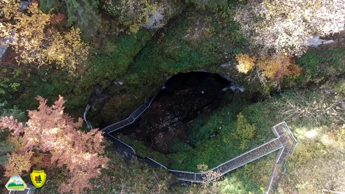
But the most sought-after place in Gârda de Sus is Peștera Scarișoara, which houses a block of ice of about 130,000 cubic meters, the largest underground glacier known in Romania.
The Scarișoara Glacier has been known as a tourist attraction since the middle of the 19th century. Since then, wooden stairs have been set up so that tourists can enter the avenue. The locals in the mountain villages used the ice and water from the glacier long before it became a tourist attraction.
Scarișoara Cave has been declared a natural monument in Romania since 1938. It is located at an altitude of 1,165 meters, has a length of 720 meters and a depth of 100 meters. The tourist route consists of an aven (vertical shaft) more than 50 meters deep and 50 meters in diameter, equipped with metal stairs.
The Scarișoara Cave consists of the Great Hall, the Church, the Small Reserve and the Big Reserve. Only the Great Hall can be visited by tourists. The Scărișoara glacier houses a deposit of fossil ice formed about 4,000 years ago. The ice block is between 11 and 36 meters thick, according to radar surveys to see what the ice structure is like at depth.